
Hiking
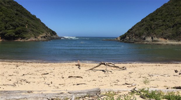
One of the best ways to explore the scenic beauty that Plettenberg Bay has to offer is by hiking the national parks, beaches and trails. Pack a picnic, and point your compass in the direction of one of the national parks in the area. Plan a day trip to Robberg Nature Reserve in Plett or the one of the beautiful walks along the coast in Nature’s Valley or the Kranshoek Coastal Walk, and enjoy walking through indigenous forests, along one of Plett’s Blue Flag beaches, or head out to Tsitsikamma and choose one of their meandering coastal trails.
One of the best ways to explore the scenic beauty that Plettenberg Bay has to offer is by hiking the national parks, beaches and trails. Pack a picnic, and point your compass in the direction of one of the national parks in the area. Plan a day trip to Robberg Nature Reserve in Plett or the one of the beautiful walks along the coast in Nature’s Valley or the Kranshoek Coastal Walk, and enjoy walking through indigenous forests, along one of Plett’s Blue Flag beaches, or head out to Tsitsikamma and choose one of their meandering coastal trails.
For a unique hiking experience, you may want to book the famous Otter Trail or try Plett’s newest adventure, The Plett Trail.
Whether you’re a seasoned hiker or are simply interested in taking a leisurely walk along the coast, there are plenty of places to wander. Remember to bring your camera, slap on the sunscreen and bring plenty of water. Enjoy your hike!
Hikes in and around Plett
There is a large variety of walks in this region ranging from under an hour to six days in duration.
No.1 Kranshoek Coastal Walk
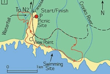
Grade: Fairly difficult
Time: 2 hours or 5 hours
Distance: 3 kms or 9 kms
Features: Forests, pine plantation, fynbos, coastal escarpment, rocky beach.
Permits: None. Please sign visitors book. Open 6am to 6 pm.
The walk is in the Kruisfontein State Forest. The route begins near the map at the picnic site. Follow the white footprints painted on trees and rocks. Once on the beach look out for paths on your left which return to the parking area.
No. 2 Robberg Nature Reserve
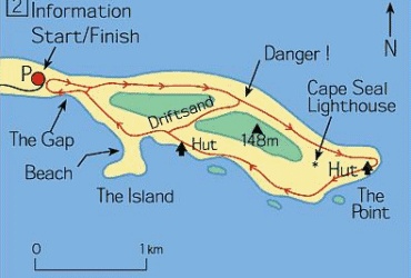
Grade: Easy to difficult
Time: 45min, 2 hours or 4 hours
Distance: 2.2kms, 5.6kms and 9.2kms
Features: Coastal escarpments, geological
highlights, fynbos, dolphins and whales.
Permits: Obtained at entrance gate.
The Robberg Peninsula has 3 circular trails. One can enjoy the large variety of coastal dune fynbos and rich marine life. The Informative Board describes the geological evolution of the Robberg. It is advisable to do this walk in cooler weather. Follow the “seal” markers.
No. 4 Hikers Paradise Trails
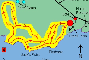
Grade: Easy to difficult
Time: 45 min, 2hours, 3 hours or 4
Distance: 2 kms, 3.5 kms, 5 kms or 7 kms
Features: Fynbos, rocky sea shores, coastal escarpment, tiergat with stalactites and stalagmites, spectacular views, dolphin & whale viewing.
Permits: None.
An entrance fee is payable at the entrance gate. The 4 circular trails are on a private farm. Only guided hikes are allowed and these hikes start at 10h00 daily (except Sundays). Hikers interested in joining these hikes must phone tel 044-5331760 for reservations. One can enjoy the large variety of fynbos, rich marine life, caves with stalactites and stalagmites, and spectacular views and have the assistance of a guide. All routes begin and end at the parking area.
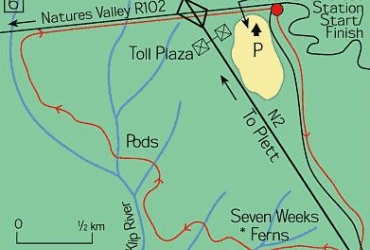
No. 5 Natures Valley Network
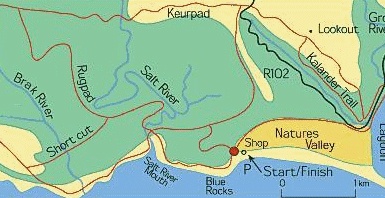
Grade: Moderate to fairly difficult
Features: Mountain scenery, fynbos, indigenous forest, optional equipment porterage
2-6 days
60kms
Permits: Free. De Vasselot campsite.
This network has numerous trails ranging in difficulty and length. Maps and information on birds and trees can be obtained at the campsite. Choose your walk carefully according to your own ability. A special place of interest and beauty is the Salt River mouth (where one may picnic and swim). The Kalander Kloof trail has magnificent big yellowwood trees and one may be lucky enough to spot the elusive Narina Trogan. Paths are well defined and junctions are clearly signposted. It is advisable to walk the coastal routes at low tide. The forest routes can become slippery after heavy rainfall. This is a hiker’s and bird watcher’s paradise with its diversity of fauna and flora. Viewpoints offer breathtaking views of the coastline and distant mountains.
No. 6 Stinkhoutkloof Trail
 Grade: Moderate
Time: 3 hours
Distance: 8.4kms
Features: Pine plantations, forests, valleys and streams
Permits: Sign book at forest station
Park at the Bloukrans Forest Station. The initial walk is along forest roads. The route crosses the N2 and winds through indigenous forest and river valleys lined with spectacular tree ferns. The paths are well marked with yellow footprints painted on rocks and trees.
No. 7 Storms River Mouth Trails
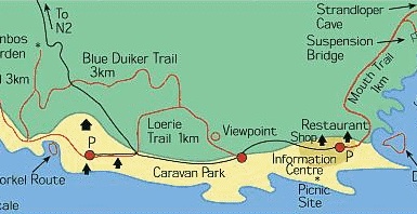
Grade: Easy to moderate
Features: Forests, fynbos, caves, suspension bridge and rugged coast
Permits: None
The Storm’s River mouth is 55kms from Plettenberg Bay. An entrance fee is payable at the entrance gate. There are four day walks, the Mouth trail (1km each way), the Waterfall trail (3kms each way), the Loerie trail (1,5km circular) and the Blue Duiker trail (5,5kms circular). These trails are similar to those of Nature’s Valley although they are more developed for tourism. A map of the walks and a list of fauna and flora species are available at the Info Centre. There is a curio shop and restaurant. Special places of interest are the “strandloper” cave, the famous bridge, the waterfall and the fynbos garden. It is advisable to tackle the Waterfall trail at low tide. This trail is the beginning of the famous Otter trail but day walkers are not permitted to go beyond the waterfall itself. One can see Knysna Loeries on the Loerie trail. They are abundant here and are breathtaking when in flight.
Originally from Plett Tourism
Share This Post